Located in central Utah, Nine Mile Canyon is a remote and picturesque canyon that boasts the most extensive collection of ancient rock art in North America.
If you like scenic drives and fun scavenger hunts, Nine Mile Canyon is a destination you don’t want to miss.
In this article, I’ll cover everything you need to know before visiting.
Nine Mile Canyon is often referred to as the “World’s Longest Art Gallery” due to its impressive concentration of rock art panels. These remarkable pictographs and petroglyphs, created by Native American cultures over thousands of years, provide a window into their lives, beliefs, and cultural practices.

Despite its name, Nine Mile Canyon is actually 46 miles long. It got its “Nine Mile” name from an early explorer and it has always been attached to the area.
The 46-mile-long road provides a lovely scenic drive as you wind through the canyon, with multiple marked stops, pullouts, and picnic areas to break up the drive.
Rock art is a catchall term for ancient drawings and carvings. Petroglyphs are etched into the rocks, while pictographs are painted on the rocks. But they are often just referred to as “rock art,” for short.

The rock art in Nine Mile Canyon was done by the Fremont Peoples, who lived here around 1,000 AD, and the Ute Indians, who lived here during the last few hundred years.
There are over 1,000 rock art panels (collections found on one wall), and over 10,000 images in Nine Mile Canyon, making it the densest collection of rock art in the world.
For context, there is rock art in Utah that is much older, called the Barrier Canyon Style. These are marked by tall, narrow figures. You can find some in the San Rafael Swell by following our 3-Day Road Trip, as well as in Horseshoe Canyon in Canyonlands.
This guide is meant to be an easy and helpful guide for the average first-time visitor – those who want to see the best of the canyon in about half a day.
With so many images to view, you could spend several days, or make several return trips to search for images. If you’re an avid rock art hunter and want to find many hidden panels that aren’t marked, see my recommendations at the bottom of this article.

Nine Mile Canyon is located in central Utah, near some other amazing places. I’ve put together a Perfect 3-Day Road Trip to discover the best of these areas, including the Little Grand Canyon and the cute town of Helper, Utah.
The canyon is open all year, so you can visit anytime. I would avoid winter due to the snow it receives. Spring and fall would be best, but the summer is fine as well because you don’t have to do much hiking.
I visited on a gorgeous spring day, and hardly anyone was in the canyon, so you never really have to worry about crowds.
The average temperatures in this area are:
Price, Utah, is usually the jumping-off point. Price has many very affordable chain hotels to choose from.
There is one location for lodging within the canyon: Nine Mile Ranch. It offers cabins and an RV park. I believe they have one room available as a bed and breakfast. They also offer tours of the canyon if you’re interested.

Nine Mile Canyon is located between Salt Lake City and Green River, just south of Price, Utah. To get there, drive on Highway 6 to Wellington, Utah, and turn northeast on Soldier Creek Road.
There is a Miller’s Travel Center gas station on the corner of the turn-off to Soldier Creek Road. Stop in here to pick up a free booklet for the canyon.
We liked this little brochure because it gave the highlights of the canyon. Other online guides felt a little overwhelming, but this focused on the must-see sites.
And make sure to fill up on gas, since there are no services in the canyon! You might also consider getting some picnic stuff here.

Carbon County has created a free audio guide for the canyon! I’m so glad I found out about this before I went because it made our experience much nicer.
To get the audio guide, download the free TravelStorys app to your phone, then search for Nine Mile Canyon. Download it so it is available offline. It is triggered by GPS points, so it will play when appropriate while you drive, or even walk to certain sites.
You can even get a little preview of the audio tour if you’d like.
The stops I list below are the same stops mentioned in the audio tour and are meant to give you an idea of what you’ll see when you go.
Download your audio guide and maps before you go, because there is no cell service in the canyon.
If you’re like us and just want to see the major sites, allow 4-6 hours to see the canyon. This includes eating a picnic at one of the two picnic sites in the canyon.
Many of the rock art sites are seen right from the roadside pullouts. Some even have metal tubes to look in to help you spot the sites on the canyon walls. Much of the canyon is privately owned, so there are even a few sites that are right by the road, but you’re asked not to walk up to them because they are on private land. The audio guide helps with this quite a bit.
There are a few sites you have to walk to. The walks are short, and they were definitely well worth it. So be prepared to do a little bit of hiking/walking.

There are no services in the canyon, so I highly encourage you to pack a picnic. There are two picnic sites in the canyon:
The Cottonwood Glen Picnic Area is much nicer. It has more trees and is located by the river. We explored the canyon first thing in the morning and ate lunch at Cottonwood Glen on our way out of the canyon.
Both have vault restrooms as well. There isn’t any water in the canyon, so be sure to bring some!

Because many of the rock art sites are located on the canyon walls overhead, I highly recommend packing a pair of binoculars. Our favorites are the Carson RD Series because we thought they were the best value, but whatever you choose, you’ll be glad you brought some.

We drove out the same way we came, but it is possible to take the turnoff near the Daddy Canyon Complex to go to Myton. This might make it easier to visit the canyon as a loop from Salt Lake City, but I can’t confirm how much time, if any, this saves.
I believe this road is mostly dirt, so do a little research before going. Also, there are rock art sites along this road. They are not covered in the audio guide, but you can find more about them below.
Once you enter the canyon (after the Nine Mile Entrance sign), all the stops are marked by signage on the road.

From Miller’s Travel Center, you’ll drive 21 miles just to reach the Nine Mile Entrance sign. The drive gets more scenic as you get closer, and into, the canyon.
There are a few sites along the way to look for:
The audio guide will cover each of these while you drive, as well as some other interesting history of the canyon.
Get our done‑for‑you, 5-7‑day route with exact drives, maps, and must‑see stops so you don’t waste time in traffic or miss the best views.
Inside the guide:
*Day‑by‑day plan for Zion, Bryce Canyon, Capitol Reef, Arches & Canyonlands to get you to the best hikes, drives, and activities
*Details You Need: Time frames, driving routes, and where to sleep each night to reduce back-tracking
*Includes audio stories to listen to as you drive
*Best Friend Guarantee: love it or get your money back

This isn’t really a stop, but it’s the only lodging in the canyon, so you can stay the night here in one of many themed cabin rooms.
As its name implies, this is the first rock art site you’ll encounter in the canyon. There are quite a few images here, but they aren’t as great as the ones you’ll see later.

This is one of two picnic areas in the canyon, but it’s also a stop in itself, as there is a historic homestead here, and you can walk down to the creek if you’d like. There is also a restroom here.

There are a few dilapidated buildings here, remnants of Harper, a small community that popped up to serve the army and other travelers going through the canyon.
This is on private property, so pay attention to the No Trespassing signs and honor them.
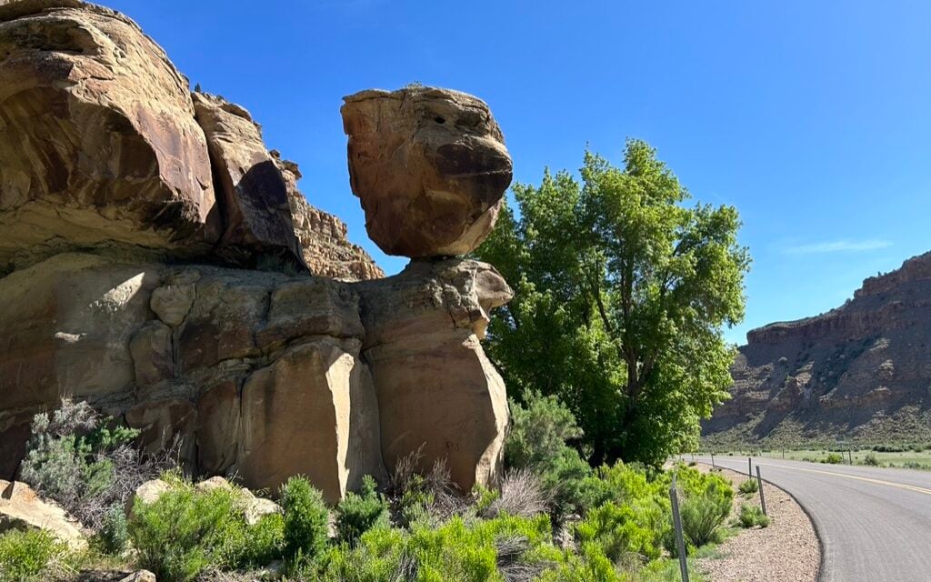
There are actually two attractions here: the strange balanced rock formation, as well as the rock art at the base of the formation.

The panel has an interesting figure that has been called the Balloon Man, the Juggler, and even Spider Woman.
This site is privately owned, so you should stay on the shoulder of the road and view the rock art using your binoculars.
This is mentioned in the audio guide, but it is the only site mentioned in the audio guide that a) isn’t marked by a sign, and b) doesn’t have a roadside pullout.
Although there is room to pull out somewhere along this stretch, we didn’t stop because we weren’t interested in searching for the inscription along the canyon wall behind the shrubbery.

This is a really cool petroglyph, but it is up high on the rocks. A viewing tube will help you locate it, but you’ll want to use binoculars to view it.
I took this photo with my zoom lens and you can see the coyote on the rock in the middle of the photo.
According to some Native American legends, the coyote god placed the stars in the Milky Way, giving us the constellations.

This panel might have been our favorite one! The highlight is the large owl with crazy eyes, but there are a few owls, a bear paw, a bear, a handprint, and more.
It requires a short walk (5 minutes) to get to the panel, at which point you’ll be standing face-to-face with the owl and other creatures.

This isn’t really a stop, but the audio guide will tell you about the interesting story of Preston Nutter as you drive by.

This is a small structure located on a cliff on the mountainside. It’s difficult to spot, so they’ve provided viewing tubes that will help you spot it quickly.
There are other village sites located at the top of the canyon, but this is one of only two structures you’ll see from or near the roadside.
These next two sites are located right next to each other, though they have separate parking lots.

Rasmussen Cave is historically significant in that it’s where scientists first started discovering and developing our knowledge of the Fremont Indians.
However, as a tourist attraction, it isn’t really much, because the cave is privately owned and you cannot go inside it.

Daddy Canyon Complex has a restroom and a covered picnic table.
It also has quite a few rock art sites located along a short hiking trail (about a mile roundtrip). The trail is circuitous – it heads into the canyon before turning right and heading back toward the road on the other side of the wash. Then you’ll go through the wash and hug the mountainside until you find the Elk Hunt panel at the end. Make sure to follow the arrows for the trail!

There are many rock art images on the hike, but the best one is the Elk Hunt, located near the end of the trail (which makes a loop at the end).
This is the only site on the road that is marked with a sign, but not covered in the audio guide. You can park in a pullout here and do a short hike up the canyon wall to see an excavated village site, as well as a nice view of the canyon below.

This is marked by a sign and has a small pullout for parking. To see this petroglyph, you’ll need to walk across the river, which is normally dry or easy to cross without getting wet. However, when we were there, the spring runoff was significant, and the river was significant enough that we couldn’t cross it.

This area has two buffalo sites: the Big Buffalo, and the Pregnant Buffalo. The audio guide discusses each of these in more detail.


This is the most significant site in the canyon and is the last site on the tour. This is one of the most well-known panels in Utah, similar to the Great Gallery in Canyonlands.
It features four hunters and a shaman figure presiding over the hunt for bighorn sheep.
It’s a short walk from the parking lot to see the panel.
This is the turnaround spot for the audio tour, and this is where we turned around as well.
Get our done‑for‑you, 5-7‑day route with exact drives, maps, and must‑see stops so you don’t waste time in traffic or miss the best views.
Inside the guide:
*Day‑by‑day plan for Zion, Bryce Canyon, Capitol Reef, Arches & Canyonlands to get you to the best hikes, drives, and activities
*Details You Need: Time frames, driving routes, and where to sleep each night to reduce back-tracking
*Includes audio stories to listen to as you drive
*Best Friend Guarantee: love it or get your money back
As I mentioned, there are thousands of images in the canyon for you to search for if you’re really interested in spending much more time here. If you want to do this, check out the detailed guides provided by Road Trip Ryan and Climb Utah.
Both of these guides provide many more images to see, and they are all GPS coordinated. Though we didn’t have GPS, we tried finding a few sites using their guides. However, we quickly lost interest as we struggled to find some of the sites, and the audio guide and marked signs provided what we felt were the best and easiest sites to see.
There are some other cool sites to see nearby in this off-the-beaten-path section of Utah. Check out our Perfect 3-Day Road Trip Through Central Utah for more!