The Grand Canyon

View of Grand Canyon

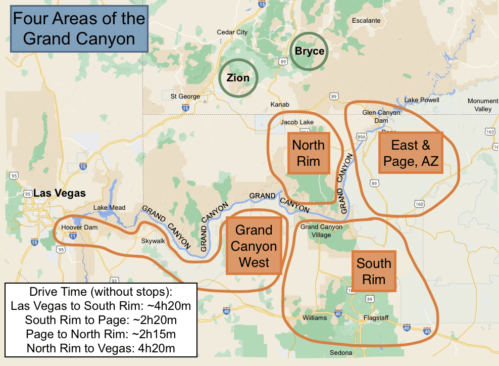
The first time you see the Grand Canyon it will take your breath away. It is one of the most amazing sites you’ll see in your life. Most people will see it for a few hours and move on. But there is so much more to the canyon than just the views. The Grand Canyon is so large, there are four main areas to the canyon, and each is hours apart from the other: South, North, East, and West.

Four Areas of Grand Canyon Map

Places

Map of South Rim

Grand Canyon South Rim

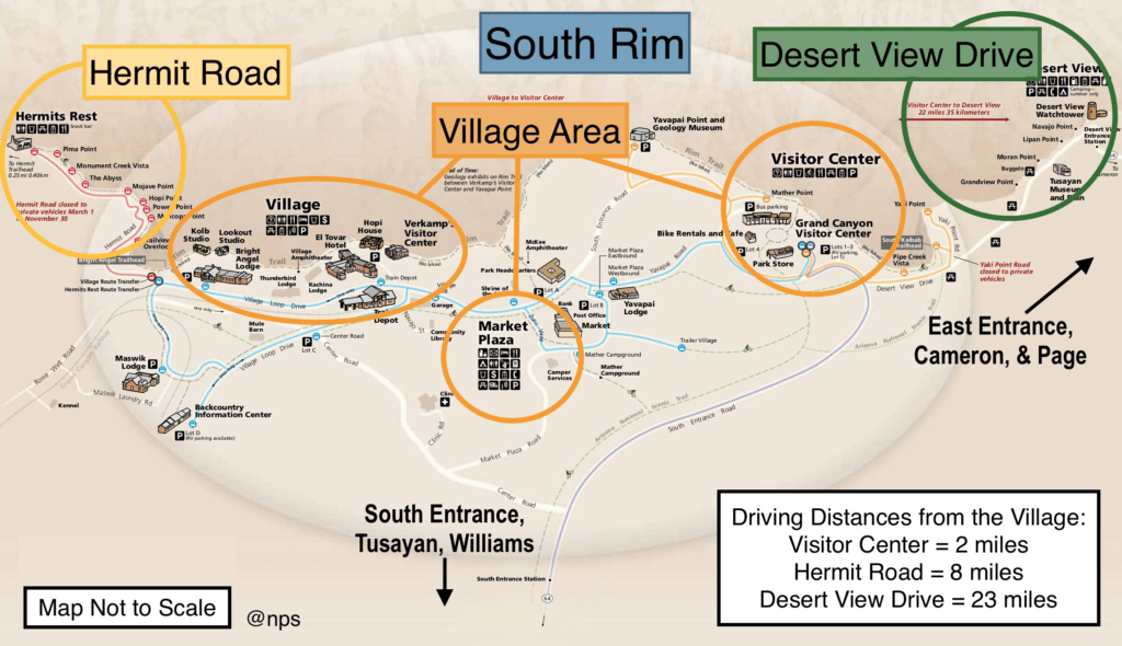
This is the main section of the national park and has the most iconic views.

  • Grand Canyon Village. The heartbeat of the national park with hikes, mule rides, lodging, and food.
  • Hermits Rest. Accessibly only by shuttle in the busy season, it’s a fun little building designed to look like a hermit’s home.
  • Desert View. Accessible by car with multiple viewpoints on the way, it provides the best views of the Colorado River below.
  • Tusayan. A small town outside the park with a visitor center, lodging, food, camping, and no charm.
  • Williams. A more charming Route 66 town with restaurants, the wonderful drive-through zoo Bearizona, and the Grand Canyon Train offering daily rides to the Grand Canyon with entertainment.
  • Sedona. Gorgeous red rock formations coupled with green trees make this new-age city a popular place to visit in conjunction with the Grand Canyon.
  • Flagstaff. Jumping off point to multiple national monuments, such as Wupatki and Sunset Crater.
Map of North Rim

Grand Canyon North Rim

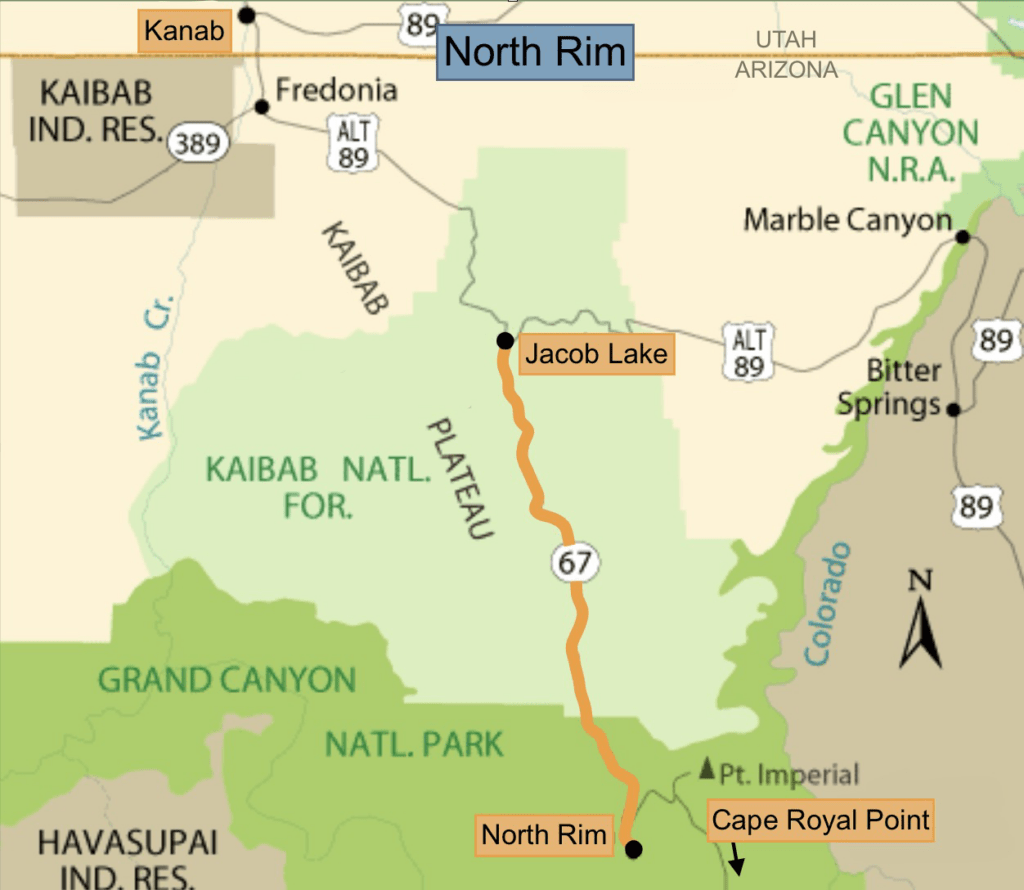
The North Rim is also part of the national park. It is visible from the South Rim and located 11 miles away as the bird flies. But it takes 4 hours to drive around the canyon to get there! Open only from May to October, it receives only 10% of the park’s visitors (read: great getaway!).

  • Cape Royal Point. Take the 23-mile Cape Royal Road out to the point for some of the best viewpoints on the north rim.
  • Kanab. Centrally located to Zion, Bryce, the North Rim, and the Vermillion Cliffs. An outdoor enthusiast’s dream, this was once known as Little Hollywood for the many movies filmed here.
  • Jacob Lake. This is the gateway town to the Grand Canyon’s North Rim. Cookies and shakes at the Jacob Lake Lodge are a must!
  • Grand Canyon Lodge. The heart of the relaxing north rim. Bright Angel Point, the Rough Rider Saloon, fine dining, and mule rides are all based out of the Lodge.

Planning a Trip to the Grand Canyon? Copy Our 5‑Day Itinerary.

Get our done‑for‑you, 2-7 day route with exact drives, maps, and must‑see stops so you don’t waste time in traffic or miss the best views.

Inside the guide:

*Step-by-step plan for the South Rim, North Rim, Page, AZ, and Grand Canyon West + a the most efficient driving routes to connect them
*Exact time frames and star ratings so you can make the best use of your time and money
*Includes audio stories to listen to as you drive
*Best Friend Guarantee: Love it or get your money back
*Visiting more in the West? Save big $ and get guides for Utah’s parks, Monument Valley, and the Grand Canyon with our Grand Circle Bundle.

Grand Canyon East Map

Grand Canyon East

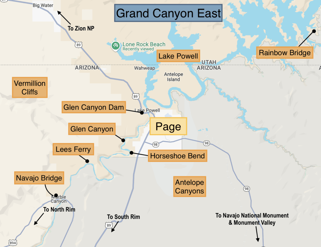
This is NOT part of the national park, this area is a collection of private, public, and tribal land. Page, Arizona, is the main city here. There are some overrated and underrated attractions in this area!

  • Page. A large (for this area) city, it’s the base for hiking and boating enthusiasts.
  • Horseshoe Bend. Overlook of the Colorado River.
  • Antelope Canyon. Confusingly, there are multiple canyons here known as Antelope Canyon, and most are accessible only through (expensive) tours.
  • Lake Powell. Famous and gorgeous lake accessible from Page.
  • Rainbow Bridge. National Monument accessible only by boat tour.
  • Navajo Bridge & Lees Ferry. Underrated places to walk over and play in the Colorado River, as well as view California Condors.
  • Glen Canyon Dam & NRA. Visitor center to learn about the dam, which forms Lake Powell.
  • Navajo National Monument. Located closer to Monument Valley, this is a nice place to see cliff-dwellings.
Grand Canyon West Map

Grand Canyon West

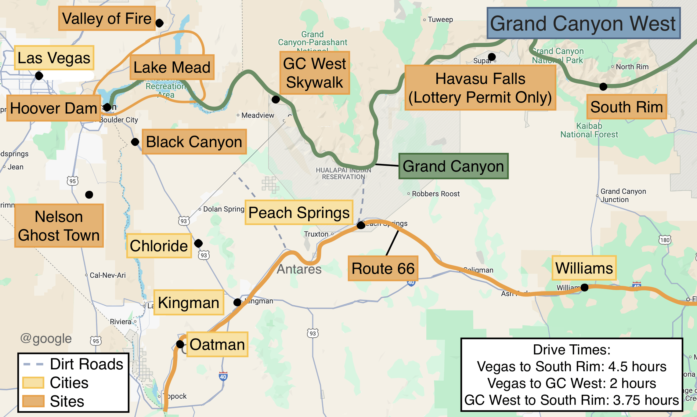
Grand Canyon West is also not part of the national park. This area is owned by two tribes.

  • Grand Canyon Skywalk. Walk out over the Grand Canyon on a see-through bridge.
  • Havasu Falls. Lottery-only hike to see gorgeous waterfalls at the bottom of the Grand Canyon.
  • Peach Springs. Route 66 town that provided the inspiration for Radiator Springs in the movie Cars.
  • Hoover Dam. Famous, massive dam with a visitor center and tours.
  • Lake Mead. This lake is formed by the Hoover dam and offers boat tours. Easily accessible from Las Vegas.

Choose the Best Part of the
Grand Canyon in 5 Minutes

See South Rim, North Rim, West Rim, and Page side‑by‑side so you instantly know which one fits YOUR dates, driving route, and priorities.

Inside the guide:

*Clear maps + realistic driving times so you know how long it actually takes to reach each area and the main viewpoints
*What to see and do in each area so you don’t stress about “missing the good stuff”  
*Where to stay nearby so you pick the right town and spend less time in the car
*Time‑ and crowd‑saving tips so you get more hours at the rim and fewer stuck in traffic or shuttle lines

Plan Your Trip

Start Here

Where to Stay and Eat

Best Hikes and Sites

Nearby

More About the Grand Canyon

Prefer to Watch?

Watch Before Visiting the Grand Canyon! [Updates, Lodging, Food, Tips]
Watch our entire Grand Canyon Playlist

Watch More

Planning a Trip to the Grand Canyon, Utah’s National Parks, and Monument Valley? Copy Our 11‑Day Road Trip.

Get our done‑for‑you, 11‑17 day route with exact drives, maps, and must‑see stops so you don’t waste time in traffic or miss the best views.

Inside the guide:

*Day‑by‑day plan for the Grand Canyon, Utah’s Parks, and
Monument Valley
*Exact times, routes, and photo stops
*Includes audio stories to listen to as you drive
*Best Friend Guarantee: Love it or get your money back