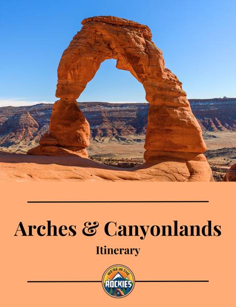
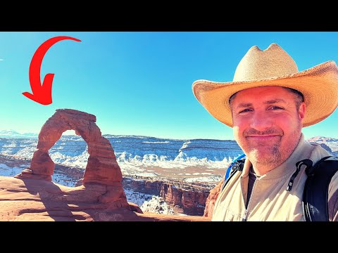
If you’re on your first visit to Arches National Park, Delicate Arch is probably at the top of your list of things to see. It is without a doubt, the most well-known arch in the world. Standing at 60 feet tall, Delicate Arch is a freestanding, curved arch that is an iconic symbol of the American Southwest.
Arches is a federally protected area that covers over 75,000 acres and includes more than 2,000 natural sandstone arches. To be considered an official arch in the park, the arch must have an opening of at least 3 feet in one direction. Delicate Arch goes well above this requirement, with an opening that is 46 feet high and 32 feet wide. There are arches with wider openings in the park, but especially because of it’s unique location and unparalleled backdrop against the La Sal mountains, Delicate Arch is second to none.
So what does it take to visit Delicate Arch? Where are the best views? And what else can you do in the area? Keep reading to find out!
The Absolute Best Time to Visit Arches National Park
How To Get To Arches National Park (Road Trip Ideas + Closest Airports)
15 Things You CAN’T MISS On Your First Trip to Arches National Park
19 Amazing Things To Do in Moab with Tips
9 Great Places to Stay When Visiting Arches, Canyonlands, and Moab
Best Places to Eat in Moab, Arches, & Canyonlands
Although Delicate Arch is the most popular sight in the area, there are several points of interest that guests in the park can visit without making the steep hike to up to Delicate Arch. Each of these points of interest can be reached via the Delicate Arch Road. This road runs east off the main park road, and takes off approximately 12.5 miles from the Visitor Center. Watch for signs, the turn is clearly marked.
This is easily one of my favorite areas of the park. Although there is clearly one main attraction, I love the diversity of the geography in this area and unique human history that is juxtaposed with the natural history.

For park guests who are not planning to complete the 3-mile round-trip hike to Delicate Arch, there are two choices of viewpoints to get a glimpse of the arch. To access these two trails, follow the road past the Wolfe Ranch Trailhead, approximately 0.8 miles, to the second parking lot labeled “Delicate Arch Viewpoint Trailhead.”
The Lower Delicate Arch Viewpoint is a few steps from the parking lot (less than 200 feet total) and is the easiest and most accessible way to see Delicate Arch. The trail has a level, hard surface, and is listed on the park website as accessible to wheelchairs.
On my last visit to the lower viewpoint, I felt the trail was more accessible than many in the park, however, it was still a little rough for a manual wheelchair user. If you are a wheelchair user or have one in your group, this viewpoint is a good option, but expect some bumps and rocky bits along the short path.
For all visitors to both the lower and upper viewpoints, binoculars or a zoom lens for a camera will make your experience much better! Although the arch is visible without magnification, it is still a good distance away. Be aware that when viewing the arch from the various viewpoints, the sandstone cliffs behind the arch can make visualizing the arch more difficult.
For a better view of the arch, still without the full 3-mile hike to the arch, guests can walk to the Upper Delicate Arch Viewpoint. This is a 0.5-mile round-trip hike, with some significant elevation gain over the short distance. You cannot reach Delicate Arch via this trail, you can only see the arch from behind.
The trail begins on a packed dirt path from the trailhead and begins to climb and narrow soon after the start. A stairway of sandstone slabs assist with the uphill climb to the viewpoint. From the top of the trail, Delicate Arch is just about a quarter mile away, across a small canyon. Binoculars are helpful to see the arch in more detail but every visitor should be able to clearly see the arch from here!
The only time I wasn’t able to see Delicate Arch, from both of these viewpoints, was two years ago in January when I visited in a major snowstorm. Visibility was reduced to a few hundred yards and made spotting the arch from below impossible. It was even difficult to see it from up at the top of the Delicate Arch trail!

In 1898 John Wesley Wolfe was 69 years old and fighting a persistent leg injury from the Civil War. He sought relief by looking for a drier climate to live in. With him on his search, he took his son Fred, but left his wife and three other children in Etna, Ohio. John and Fred settled a 100-acre ranch in the Salt Valley, located below Delicate Arch. When John’s daughter Flora joined them years later she insisted they improve their living conditions and they built a new cabin. It is still standing today. At one point, all six family members lived and slept in the one-room cabin.
The Wolfe Cabin is accessible and is less than 300-yards from the Wolfe Ranch Trailhead parking lot. The Wolfe Ranch Trailhead is at the start of the Delicate Arch Trail. The trail is wide and has packed dirt all the way to the cabin. It may be bumpy for wheelchairs or mobility aids.

Located another quarter mile up the Delicate Arch Trail is evidence of people who lived in the valley long before John Wolfe and his family. For centuries before the arrival of European pioneers, people from the Hopi, Zuni, Ute, Piute and other hunter-gatherer Indigenous tribes lived in the area around Moab and Arches National Park.
Some of these tribes left petroglyphs throughout the area. The petroglyphs near Wolfe Ranch have been attributed to the Ute tribe. The style of the horse and rider surrounded by bighorn sheep is characteristic of Ute artwork.
These petroglyphs were created between 1650 and 1850 AD and have survived hundreds of years. If you choose to visit any petroglyphs in the Moab area, please be respectful of their historical and cultural significance to the descendants of the tribes who created them. Do not touch the art or rocks around the art. Even the natural oils of your skin can increase the deterioration of the petroglyphs.
Viewing the petroglyphs is a great addition to the Delicate Arch hike, or as a short hike to the Wolfe Ranch and petroglyphs alone. The walk to the petroglyph panel and directly back to the parking lot is approximately 0.5 miles. Like the portion to Wolfe Ranch, the trail to the Ute Panel is also relatively wide with packed dirt. It also has some elevation gain, as well as, bumps and gravel that may cause difficulty for wheelchairs and mobility aids.

The main event! The thing you have been waiting for! The Delicate Arch was formed over millions of years through erosion and weathering. The arch is made of sandstone which was formed from ancient sand dunes that were buried and compressed into rock.
Tens of thousands of years later, the rock was again exposed. It began to erode. Water seeped into the cracks and froze. The expanding caused the cracks to grow wider. The wind then blew away the loose debris gradually carving the arch’s shape. Different minerals in layers of sandstone are harder and more resistant to erosion. This has caused the unique shape of the arch, and has allowed the arch to remain standing even as the rock around it continues to erode.

The hike to Delicate Arch is a moderate to strenuous, 3-mile round-trip hike that begins at the Wolfe Ranch Trailhead. The trail features rocky terrain, a steep and prolonged incline, and some light scrambling.

I say the trail is “moderate to strenuous” because in my opinion, the biggest factor in the difficulty of the hike is the weather. Although the terrain is steep, I have seen my 80+ year-old great-grandmother and 60+ year-old grandparents complete this hike. I have passed guests of all ages and abilities on this trail.

I fully believe that most guests could complete the Delicate Arch hike if they take their time and are able to walk the distance. However, because of the extreme heat in the summer, it may not be reasonable to take a prolonged period of time to complete the hike. A large portion of the hike is one long exposed climb up a slick rock hill (slick rock is not actually slick). In the summer, the rock further intensifies the extreme desert heat by radiating the heat back off the rocks. There is no shade to provide relief until you near the top of the hike.

If you are visiting on any day when the temperature is forecast to be over 60 degrees, expect that the hike to Delicate Arch will feel much warmer than forecast. We have a whole article on hiking in the desert that provides important tips to stay safe. At the very least, carry 1-liter of water (or more) for each hiker, and avoid hiking in the middle of the day when the sun exposure is the highest.
After you complete the main climb, there are a series of steps up layers of sandstone and another exposed climb up to Twisted Doughnut Arch. If you can scramble up to Twisted Doughnut, it provides an amazing unique view of Delicate Arch. Once past Twisted Doughnut, you’ve arrived! Take your final steps up the sandstone ledge, and enjoy the beautiful view of the Delicate Arch and the La Sal Mountains behind.


This view of Delicate Arch can get crowded even during the off-season, and especially at sunset during the spring, summer, and fall. Plan ahead and try to visit in the morning or earlier afternoon to avoid some of the crowds. Do not expect to be alone at the top of the trail. If the parking lot at the Wolfe Cabin Trailhead is full, additional parking is available farther down the road at the Delicate Arch Viewpoints trailhead but will add a significant distance to the hike.
My favorite tip to find a parking spot is to do a few slow laps around the parking lot and watch for guests returning to their cars or packing up their trunks. Because hikers start at varied times and hike at varied speeds, there is rarely a time when someone isn’t returning to their car within 10-15 minutes. However, there may be times that the crowds are simply so heavy that even this tip doesn’t produce a parking spot within a reasonable time. However, it’s worth a few minutes to try!

Despite their large size, Arches and Canyonlands National Parks do not have any restaurants or general stores within their boundaries. When visiting, you’ll need to plan ahead and bring food to eat inside the park or plan to return to Moab for your meals.
Make sure to take plenty of snacks to keep your energy up while hiking. Remember to include some salty snacks to help prevent dehydration. See our article Best Places to Eat in Moab, Arches, and Canyonlands for recommendations on dinner. After a day of hiking, you deserve a good meal.
Yes! Arches National Park is super close to Moab but Arches can be tricky to get into. The National Park Service has implemented a reservation system that limits the number of visitors allowed to enter each day. Reservations are required during peak season (roughly April – September).
If you are visiting during peak season, you may not get to enter. Make sure you are prepared and have backup options.
Most travelers want to visit the most popular sites and still avoid crowds. We have a detailed itinerary for Moab, Arches, and Canyonlands. It will give you a step-by-step game plan so you can get to the best places at the right times.
ARCHES & CANYONLANDS TRIP PLANNER: To read or watch all of our content about Arches National Park & Canyonlands National Park, check out our Arches Homepage and our Canyonlands Homepage
ARCHES: Don’t miss all that Arches has to offer including hiking to Delicate Arch, and visiting Devil’s Garden, Fiery Furnace, & the Windows
CANYONLANDS: Visit the different areas of Canyonlands with our easy guide including the Island in the Sky District, the Needles District, and Horseshoe Canyon. Check out some amazing viewpoints, as well as, Mesa Arch, ancient ruins, and Native American rock art
MOAB: Explore the adventurous Moab area including Corona Arch, Gemini Bridges, and Dead Horse Point State Park. Consider taking a jeep ride, a horseback ride, rafting down the Colorado River, or taking a scenic drive and exploring Potash Road
WHERE TO EAT: Don’t miss the best places to eat in Moab, Arches, & Canyonlands
WHERE TO STAY: Learn all about where to stay when visiting Moab, Arches, & Canyonlands
WATCH: Enjoy videos of gorgeous Arches National Park & Canyonlands National Park while learning our best tips for visiting by watching our Moab, Arches, & Canyonlands YouTube Playlist