Visiting Moab, Utah, and thinking about driving to Gemini Bridges?
Gemini Bridges are two bridges, or arches, located next to each other in a canyon near Moab, Utah. It is a popular destination because it’s a cool formation, and the road to get there is a nice beginner Jeep trail.
But you don’t have to be an off-roader to visit these cool bridges! There are two ways to get there. In this article, I’ll cover both, as well as what you can see at the Bridges.

Gemini Bridges is located about 20 minutes north of Moab, Utah.

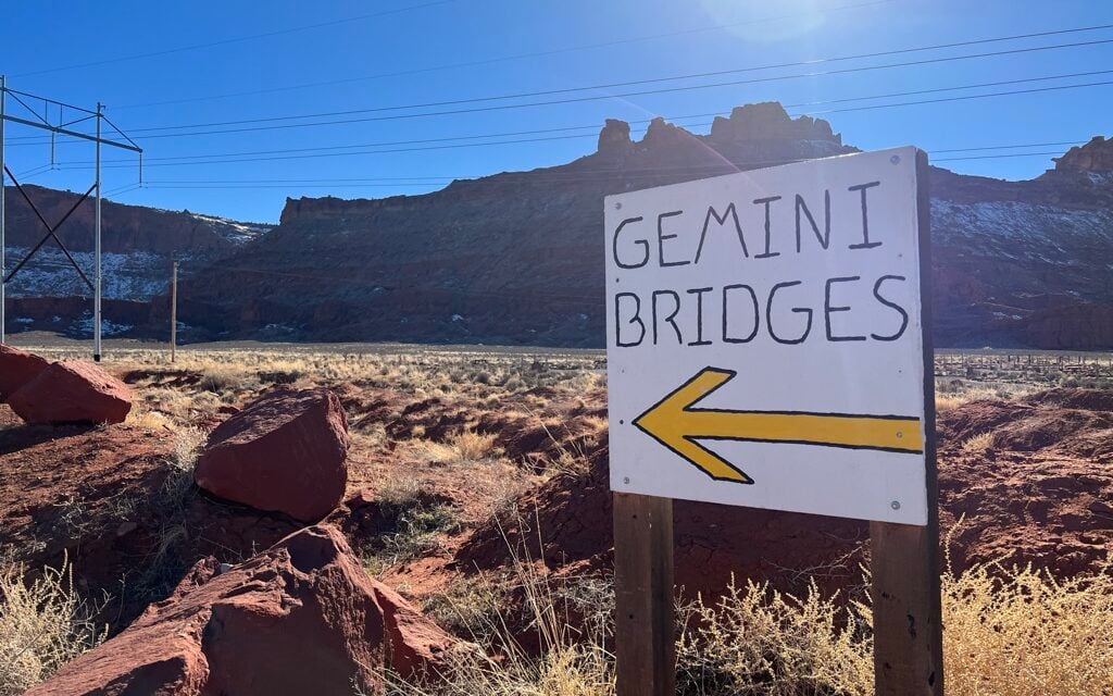
Gemini Bridges is accessible from the Gemini Bridges road, which is entirely a dirt road.
There are two ways to access the road: from Highway 191, and from Route 313. The Gemini Bridges formation is located right in the middle of the two entry/exit points.

Free 5-page guide – Exactly how to see Delicate Arch, with or without the full hike, plus when to go and what else to do nearby
Inside the guide:
*5-page Printable – Exactly how to see Delicate Arch, with or without the full hike, plus when to go and what else to do nearby
*Best times of day to go so you avoid the worst heat and crowds
*What to combine with Delicate Arch so you know what else to do in Arches that day instead of guessing
The entire road is about 13 miles, and the Gemini Bridges Formation is located about in the middle. With all the bumps in the road, it took me about an hour, going slow in my Toyota Sequoia, just to get to the Gemini Bridges parking lot. The ride out was much faster (see below).

The most common entrance is from Highway 191. That’s because this is an off-road trail, and Moab is famous for off-roading.
This is the “fun way.”
Gemini Bridges is considered a beginner off-road trail.
I did this in my Sequoia, and although it was able to handle it, I was afraid of damaging my vehicle the entire time. I loved the road, but I did not love my experience because I was driving my SUV.
I’d love to drive the road again in a side-by-side or a Jeep.

Route 313 breaks off Highway 191 and leads to Dead Horse Point State Park and Canyonlands National Park. But it can be used to skirt around the rough off-road portion of Gemini Bridges road.
The dirt road between Route 313 and Gemini Bridges is generally flat and accessible by car or van.
I drove this on my way out of Gemini Bridges and was surprised to find it in such good shape. That’s because the Jeepers go to the Bridges, and maybe some other trails (like Metal Masher), then turn back.
This is the road less traveled. Though it’s not scenic like the other road, it can be used to access the very cool Gemini Bridges.
After you turn onto Gemini Bridges road from Route 313, at 3.9 miles you’ll encounter a four-way intersection. Turn right. At 4.7 miles you’ll see a three-way intersection. Turn left. At 5.5 miles you’ll encounter another four-way intersection. Turn right. In 0.1 miles you’ll see the parking lot.
Google Maps has this mapped out and will easily get you there from Route 313.

Once you arrive at the parking lot, you’ll need to complete a 0.4-mile round-trip hike to get to the flat-topped bridges. The flat and easy trail is marked mostly by green paint marks on the slick rock. Upon arrival, you’ll be standing at the top of a little canyon.


There are two bridges right next to each other that you can walk on with sheer drops on each side.
Venture around the area – you’ll see a plaque for someone who died in an ATV accident here, and you’ll see a beautiful canyon view.

When leaving, make sure to return the way you came back to Hwy 313. If you go towards Hwy 191 you’ll be on the off-roading trail.
Get our done‑for‑you, 5-7‑day route with exact drives, maps, and must‑see stops so you don’t waste time in traffic or miss the best views.
Inside the guide:
*Day‑by‑day plan for Zion, Bryce Canyon, Capitol Reef, Arches & Canyonlands
*Details you need: Time frames, driving routes, and where to sleep each night to reduce back-tracking
*Includes audio stories to listen to as you drive
*Best Friend Guarantee: love it or get your money back
It’s also popular to bike and motorbike in this area. For more information about the biking trails, see the Bureau of Land Management website.
Gemini Bridges is worth the visit, especially if you have a vehicle that can handle the bumpy road from Highway 191.
If you don’t have the right vehicle, it’s still worth the short detour from Route 313 on your way back to Moab from Canyonlands or Deadhorse Point.
It’s a beautiful little canyon and a fun place to wander around for a half hour.
There is so much to do in Moab, Arches, and Canyonlands. How do you know what you should see and do? You need help! Don’t miss out on the best things.
Most travelers want to visit the most popular sites and still avoid crowds. We have a detailed itinerary that gives you a step-by-step game plan so you can get to the best places at the right times!
ARCHES & CANYONLANDS TRIP PLANNER: To read or watch all of our content about Arches National Park & Canyonlands National Park, check out our Arches Homepage and our Canyonlands Homepage
ARCHES: Don’t miss all that Arches has to offer including hiking to Delicate Arch, and visiting Devil’s Garden, Fiery Furnace, & the Windows
CANYONLANDS: Visit the different areas of Canyonlands with our easy guide including the Island in the Sky District, the Needles District, and Horseshoe Canyon. Check out some amazing viewpoints, as well as, Mesa Arch, ancient ruins, and Native American rock art
MOAB: Explore the adventurous Moab area including Corona Arch, Gemini Bridges, and Dead Horse Point State Park. Consider taking a jeep ride, a horseback ride, rafting down the Colorado River, or taking a scenic drive and exploring Potash Road
WHERE TO EAT: Don’t miss the best places to eat in Moab, Arches, & Canyonlands
WHERE TO STAY: Learn all about where to stay when visiting Moab, Arches, & Canyonlands
WATCH: Enjoy videos of gorgeous Arches National Park & Canyonlands National Park while learning our best tips for visiting by watching our Moab, Arches, & Canyonlands YouTube Playlist