When you visit South Dakota, there are many things to do outdoors. While in Custer, South Dakota, many people go on the confusing Black Elk Peak hike. However, how do you navigate this tricky hike?
The best way to hike the Black Elk Peak hike is to begin at the trailhead and take one of the trails to the summit. Bring plenty of water and snacks to consume during this moderately difficult hike. Stay on the chosen trail and follow trail markers to avoid getting lost.
If you are an avid hiker, consider going on the confusing Black Elk Peak hike. Keep reading to learn more about it and what you should do while going on this hike.
Get our done‑for‑you, 4-7‑day route with exact drives, maps, and must‑see stops so you don’t waste time in traffic or miss the best views.
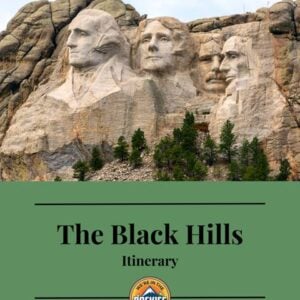
*Day‑by‑day plan for Mount Rushmore & the Black Hills
*Exact times, routes, and photo stops
*Includes audio stories to listen to as you drive
*Best Friend Guarantee: Love it or get your money back
Black Elk Peak was originally called Harney Peak. It was originally named after Army General William S. Harney. Harney was later accused of massacring many Native Americans. The Lakota people fought for years to get the name changed. On August 11, 2016, they succeeded. The peak was renamed Black Elk Peak in honor of a Lakota Sioux medicine man named Black Elk.
Some trail maps or even locals may still refer to it by its original name.
There are multiple trailheads and routes to the top of the peak. Choosing which route to take up and which route to take down can get confusing.
I’ll share what I did as well as some other hike options later on.

Many of the most accessible and popular trailheads begin near or around Sylvan Lake in Custer State Park.
There are many ways to get into Custer State Park, depending on where you are coming from. The best and most direct way is to go west on Highway 16, about 30 miles from Rapid City through Hill City. Continue about 3.2 miles and turn east onto Highway 87. Follow this road for 6.1 miles to the Sylvan Lake day-use loop road.

Vehicles traveling non-stop through Custer State Park on US Hwy 16A do not need an entrance license.
Three of the trails we discuss require you to park inside Custer State Park. You will need to pay a fee to enter and park. The fee is around $20 per vehicle for a 7-day pass (check the park’s official page for current pricing).
The other two trails do not require a fee because you will not be parking inside the park.
There are multiple trailheads for this hike, each with its own parking lot. Getting there early in the morning is the best way to ensure a great parking spot!

The most common place to park is Sylvan Lake. If possible, forgo the first parking lot (next to the General Store) and drive on the Day Use Road next to the lake. It will take you to a larger parking lot, which also has a dirt overflow parking lot next to it.
Trails #9 and #4 depart from here (see the trail map above). Trail #9 is located at the north end of the lot, and #4 is on the south end of the lot.
An entrance fee is required for these two trailheads.
There are also two trailhead parking lots located on Highway 87, just to the east of Sylvan Lake: one for Trail #4, and one for the Cathedral Spires Trailhead. Both trailheads lead to Black Elk Peak.
Both require an entrance fee.

The parking lot for Trail #3 (Norbeck Trail) is located a few miles farther east and just off Highway 87.
To get here, you will turn onto Camp Remington Road from the Needles Highway (87A). Go 0.4 miles to Iron Creek Horse Camp Road. Turn left and go 0.5 miles to the camp and trailhead, which is located on the west side of the campground.
There are restrooms at all of the parking areas, but none on the trail. Make sure to go before you go!
| Trail | Miles Round Trip | Elevation Gain | Time |
| Trail #9 (9S) | 7.1 miles | 1469.8 ft | 2-4 hrs |
| Trail #4 | 7 miles | 1262.2 ft | 3 hr 10 min |
| Cathedral Spires | 7.2 miles | 1532.2 ft | 3 hr 40 min |
| Trail #9 North (horse) | 10 miles | 2480 ft | 5 hr 30 min |
| Norbeck | 11.3 miles | 2076.8 | 5 hr 25 min |
The most popular and probably the easiest is Trail #9 (often called 9S). It is about 3.5 miles each way and has a very wide path most of the way. Not only is the uphill gradual, but it has some downhill along the way, which breaks up the climb.


A lot of people take Trail #4 on the way back, making a complete loop from starting at #9. Or you can do this in reverse.
I think taking #9 up and #4 back is easier. This option is very popular, and #4 has some great views of the Needles, as well as some spur trails.
NOTE: Trail #4 and Trail #9 are connected by Trail #3 (just to make it more confusing!)
The spur trails from #4 include Little Devils Tower and Cathedral Spires, which are both strenuous and technical hikes. Both have some rock scrambles, but are worth it if you have the time and energy.
These are trails that can be done on their own as well, but if you want to add them to your Black Elk Peak hike, then you can kill two birds with one stone.

This is another out-and-back trail. It is about 7.2 miles long and starts out quite a bit rocky and steep. This route will also have amazing views of the Needles and meet up with Trail #4.
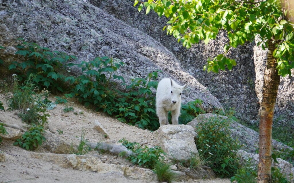
Although it is possible to see wildlife on all of these trails, the Cathedral Spires trail has a better chance of seeing mountain goats, which are my favorite in the park.
Parking for this trailhead is going to be the toughest. Located on the Needles Highway, the trailhead is along a switchback section of the road and has very limited parking.
If you are using this trailhead, make sure to get there early during peak season.
Otherwise known as Trail #3, the Norbeck Trail is much longer and some say more scenic. I am less familiar with this trail, but from what I’ve read, the trail is far less populated and at times follows along Iron Creek. This trail also allows dispersed camping.
This trailhead is just outside of the Iron Creek Horse Camp and doesn’t have day-use parking in the camp.
Some areas are said to be very steep and mountainous and it’s 11.3 miles out and back.
This is more for avid hikers and horseback riders. It is labeled hard. It is over 10 miles long and takes 5-6 hours to complete.
Dogs are welcome on these trails and off-leash is acceptable in some areas.
Each route will showcase its own beauty and scenery and of course, the season you hike will also play a factor. The views are spectacular on the trails and at the top.
Mountain goats, squirrels, chipmunks, elk, deer, big horn sheep, birds, and raptors are in and around the Black Elk Wilderness area.
DISCOVER: What to See While Driving the Wildlife Loop in Custer State Park in South Dakota.
The needles and the surrounding mountains are full of spectacular rock formations and colorful granite spires. The scenery in this part of the Black Hills is what brought me to revisit and eventually move to the beautiful state of South Dakota.

The dynamic display and mixture of trees and foliage make each season in the forest indescribable. Spring and summer yield greenery and wildflowers in abundance, dancing with fuzzy bumble bees and butterflies.
Fall colors explode and vibrantly contrast the almost always blue skies along the trails and cover the floor with a carpet of colorful leaves. It’s my favorite time to hike, especially given the cool temperatures.

Early winter has its own charm when things turn brown and start to look desolate. If you catch the right day, you can see the crystal gleam of snow and ice along the trail, barring the roads are open.
These are ties made from cloth left by the Lakota or Cherokee people as offerings of prayers, intentions, or gratitude. They are tied to trees or sacred places.

Unexplainable! It’s something you have to do and see for yourself, but I will try to describe it. You’ll feel like you’re on top of the world. The magnitude of how high up you are doesn’t settle in until the last several layers of stairs.
I stopped many times to see everything from a new perspective and to take a few minutes to catch my breath.
We took dozens of pictures at the top, but the camera just can’t do the views justice, nor can it grasp the depth of the distance. Your eye can only see so far and regrettably, I forgot my binoculars.
There are surprises and unexpected twists and turns when you get close to the top, making it suspenseful and fun. In one section, we climbed into a tunnel and started our ascent into the tower.


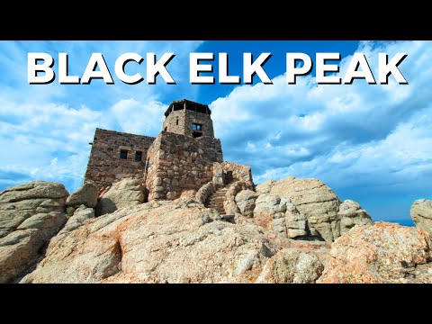
The very top of the summit has an old stone fire lookout that was built in 1938. This tower served as a fire lookout until 1967 and is now only used by hikers.
You can go all the way to the top of the lookout and peer out the windows, which gives you the 360-degree panoramicview that enticed you up there in the first place!
There are a lot of areas to explore and scramble over rocks and stairs. We brought snacks, took a break, and wandered around.
As I mentioned at the beginning, you can see four states on a clear day. I wish they had a map with arrows at the top so I could get a general idea of what I was looking at.
There are many great spots to take selfies or pictures with your hiking pals. We did come across other hikers and took turns taking pictures for them and vice versa.
Definitely don’t miss a chance to get a picture with breathtaking views behind you.
May through September is the most popular and best weather choice. However, you can sneak a hike in October or April if the weather is cooperative.
Winter is a challenge because of road closures and weather.
Personally, I think spring, early summer, or early fall would be the best weather and prettiest scenery along the hike, with wildflowers and butterflies for company.
In the summertime, you can pick wild blueberries and raspberries along the way for a sweet treat.
FIND OUT: The Best (and Worst Times) to Visit the Black Hills and Mount Rushmore
Early morning is the best time of day to hike. You will beat the crowds and ensure you get a parking spot! In addition, morning temperatures are much more pleasant than the afternoon sun and heat.
Many people come to see the sunrise or sunset. I would start the hike at least 2 hours before sunrise or sunset to be sure I made it in time to not miss out! Of course, you’ll be doing half your hike in the dark, so bring a headlamp.

Step‑by‑step emails and a printable quick‑start planner so you know exactly when to go, where to stay, and what to do (besides Mt. Rushmore)
You’ll learn:
*Best time to visit and how many days you actually need
*Exactly where to stay in the Black Hills, plus a Quick Start Planner PDF you can print or save on your phone
*Best local places to eat so you don’t waste meals on mediocre spots
*Road trip route ideas (with an audio sample) so you’re not guessing what to see next
*What to do beyond Mt. Rushmore so your whole trip is memorable, not just one stop

The hike took us 3.5 hours total and I think that is average. The longer you stay at the top and the more breaks you take, will ultimately affect this time, as well as which trail you decide to start from.
The most popular trailheads take between an average of 3 hours and 10 minutes to 3 hours and 40 minutes. Take your time and enjoy every minute of it and don’t worry about making it in that “average” range.
Horseback riding is also very popular in the Black Hills. There are many wonderful horse camps in the area, lending enthusiasts a great place to vacation with their horses and explore more ground in the hills.
The most popular ride is from the Willow Creek trailhead, taking the #9 trail up and coming back through Lost Cabin trail.
Tie-ups are available at the base of the tower, as horses are not allowed past that point.
Shoes are recommended for horses.
Make sure to bring water and plenty of it. There is no water on these trails, so be smart and bring more than you think you will need. We wore hydration packs, which are recommended, especially on hot summer days.
Bring trail snacks or a lunch for a picnic at the top. We brought some fruit and trail mix with us on the hike and left our lunch inside our car for when we got back. We enjoyed our sandwiches in the picnic area near the lot and then drove into the town of Custer for some excellent hot coffee, as the day was brisk. Don’t miss The Best Places to Eat in Each City of the Black Hills for some great dining spots.
If you have binoculars or a compass, they could make the journey that much more interesting. Neither is needed to follow the trails up, but the compass may help you discover what direction you are looking. Binoculars are never a bad idea!
Watch the weather and dress accordingly. We started our hike when the temperature was in the mid-’30s and it was freezing, but it didn’t take long to warm up.
If it’s cold, I would bring some tissues for your runny nose, and layer your clothing so that you can remove pieces as you warm up. I had a long-sleeve shirt under a hoodie and that ended up being perfect for the temperature outside.
If you like added support, don’t forget to bring your hiking sticks with you. They are especially good for the more rocky terrain you will encounter on some of these trails.
This trail is mostly open with full sun exposure, so be sure to protect yourself from getting burned.
I will never forget to bring Chapstick on long hikes again. Throw some in your pocket or backpack just in case!
Good, comfortable shoes are a must. I actually wore some comfy non-slip sneakers and they were fine, but hiking shoes are always the best option. If you only have sneakers and decide to do the hike last-minute, I think you will be fine. One person in our group even had Vans on.
See our recommended gear page or our Amazon shop for our favorite hiking gear.
If it’s a nice summer day, you can look forward to a nice dip in Sylvan Lake. The lake is beautiful and thriving all summer with families swimming, kayaking, fishing, and paddleboarding. If the temperatures reach 90 degrees and above it will really be refreshing.
The trail only allows groups of 25 or fewer heartbeats. I gather that includes your furry friends and, yes, dogs are allowed on the trail as long as they are on a leash.
Dispersed camping is allowed anywhere in the Black Elk Wilderness EXCEPT 1/4 mile from Black Elk Peak and trail #9S coming out of Sylvan Lake. Read more about camping in the Black Hills in our article Does Mount Rushmore Have a Campground? (Best Campgrounds When Visiting).
Fill out a free wilderness permit at the self-registration kiosk when entering the area. I will admit I didn’t know this at the time, nor do I remember seeing this kiosk. Upon further investigation, I’ve found it’s easy to miss and it’s often out of permit papers, but to be safe, find it and fill out a permit.
As I’ve mentioned, some of the routes above have either spur trails or some hikes that intersect onto Black Elk Peak, but they can be done alone. I’ll include some additional hikes in the area now.
This one-mile loop around the lake is very easy and one of my favorite quick hikes anytime I visit Sylvan Lake. I highly recommend it!

This 2-hour trail is just under 4 miles and starts directly behind Sylvan Lake. The trail is labeled as hard and I’ve heard that it feels more like 6 miles. There is mention of rock scrambles and climbing from rock to rock.
Gripper gloves are recommended for this one and watch out for slippery conditions in the colder weather. I’d save this hike for summertime.

This has become my favorite trail in the Black Hills so far. It’s a moderately easy trail that is only 1.6 miles total, out and back. The scenery is some of my favorite with a great chance to see mountain goats and other wildlife. Look out for deer and marmots too. The only drawback is the tiny parking area, so arrive early!
Stockade Lake trail is another on my list. This is a moderate 1.4-mile loop where you can take in a view of Stockade Lake and if you have your binoculars, you can see the Crazy Horse Monument.
Don’t miss more great hikes in the Black Hills: The Amazing Devil’s Bathtub Swimming Hole in South Dakota and Gorgeous Roughlock Falls in Spearfish Canyon, South Dakota.

Of course, you can not come to the Black Hills without seeing our national treasure, Mount Rushmore. Do not miss this extraordinary memorial of George Washington, Thomas Jefferson, Theodore Roosevelt, and Abraham Lincoln. Read 13 Great Things To Do When Visiting Mount Rushmore National Memorial for more.
FIND OUT: When Is The Best Time To Visit Mount Rushmore? and How Much Time Do You Need At Mount Rushmore.

One of my favorite things to do in the Black Hills is to drive through the park. Custer State Park has over 71,000 acres featuring lakes, glorious views, wildlife and so much more.
CHECK OUT: Custer State Park’s Annual Buffalo Roundup.

Take a ride on an original steam engine train from Hill City to Keystone and back. You can spend some time shopping and grab a bite to eat while you are at it. For further information, read about my experience on the 1880 train.
DON’T MISS: 40 ABSOLUTE Best Things To Do in the Black Hills

There is no shortage of scenic drives in the Black Hills. The Needles Highway is just a hop, skip, and a jump away from the trailheads of Black Elk Peak, so make sure you hit that up after the hike! For a sneak peek of Needles Highway, see our article 11 Gorgeous Scenic Drives You Have to See to Believe.
CHECK OUT: 9 ABSOLUTE BEST Things to Do in Badlands National Park (+ Quick Guide)
Yes! The Black Hills and the surrounding area can be confusing because it’s huge and there are so many things to do!
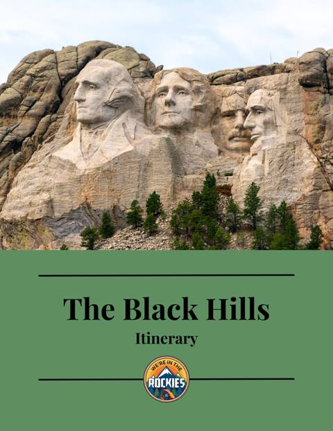
Do you need a game plan so you don’t miss out on the best things to do in the Black Hills? Check out our Mount Rushmore/Black Hills Itinerary.
Most travelers want to visit the most popular sites, yet still avoid the crowds. We have a detailed itinerary that gives you a step-by-step game plan so you can get to the best places at the right times!
But that’s not all! Our itinerary includes a free audio guide to listen to while driving, with over 2-hours of stories about the area!
BLACK HILLS TRIP PLANNER: To read or watch all of our content about the Black Hills, check out our Black Hills Homepage
AREAS: The Black Hills is home to some amazing national parks and monuments: Mt. Rushmore, Wind Cave and Jewel Cave National Parks, Badlands, and Crazy Horse. Plus, the amazing Custer State Park
THINGS TO DO: There are so many more things to do than hike and look at Mt. Rushmore. Explore the 1880 train, Reptile Gardens, slip down a natural waterslide, or go on a scenic drive
GREAT CITIES TO STAY OR CHECK OUT: Explore some amazing mountain towns, including Deadwood, Keystone, Hill City, and Rapid City plus where to stay or camp while visiting
GET QUIRKY: Want something REALLY different? Check out Devils Tower and Wall Drug
WHERE TO EAT: Check out the best places to eat in and around Mt. Rushmore.
WATCH: Enjoy videos of the amazing Black Hills while learning our best tips for visiting by watching our Black Hills YouTube Playlist